

Remnants of Ida Cause Massive Flooding in the US Northeast
September 2
The remnants of Hurricane Ida slammed the Northeast region with torrential rains causing heavy flooding. Massive damage to infrastructure and property was reported, including power outages affecting more than 200,000 residents. New York declared a state of emergency early Thursday morning as it battles heavy rainfall – in some places 3 to 4 inches an hour.
Rainfall estimates for parts of central and eastern Pennsylvania and New Jersey ranged from 4 to 8 inches of water with some isolated locations approaching 10 inches. The National Weather Service issued five flash flood emergencies stretching from Philadelphia through Northern New Jersey.
Multiple tornadoes were reported, homes were flooded and water rescues were ongoing in eastern Pennsylvania, western New Jersey and in Maryland.
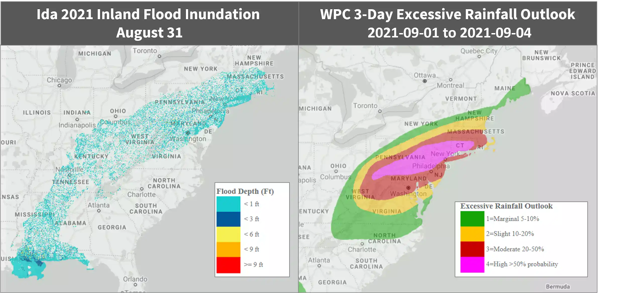
Follow the quick links to assess the impact in EigenPrism:
- Ida 2021 Inland Flood inundation footprint – as of 2021-09-01
- WPC 3-Day Excessive Rainfall Outlook – from 2021-09-01 to 2021-09-04
- US Flood Outlook – as of 2021-09-01
August 30 | Category 4 Hurricane Ida Slammed Louisiana with Devastating Winds
On Sunday afternoon, Ida made landfall near Port Fourchon, Louisiana, as an extremely dangerous Category 4 hurricane with winds of 150 mph – same day as the 16th anniversary of Hurricane Katrina.
Ida caused massive damage in southeast Louisiana on Sunday. Bands of heavy rain containing gusty winds are spreading from Southeast Louisiana into Mississippi, Alabama and the Western Florida Panhandle, as per the NHC.
According to the National Hurricane Center, Hurricane Ida has now weakened to a tropical storm today and is currently located about 95 miles SSW of Jackson Mississippi with maximum sustained winds of 60mph. The threats of flooding rainfall and isolated tornadoes will continue to spread inland from South into parts of East through the week. Storm-surge flooding and strong winds will also linger near the northern Gulf Coast states today as Ida winds down.
Ida is forecasted to weaken to a tropical depression later today over Mississippi and then track through the central Appalachians, and further into mid-Atlantic later in the week.
Ida is tied for the most powerful storm on record to hit Louisiana, matching the strength of Laura from 2020 and the Last Island Hurricane of 1856.
Follow the quick links to assess the impact in EigenPrism:
- TropStorm Ida Past Wind Swath Advisory 18A – as of 2021-08-30
- Hurricane Ida 2021 5-day Past Max Winds – as of 2021-08-30
Aug 27 | Tropical Storm Ida Forecasted to Hit US Gulf Coast as a Major Hurricane
According to the National Hurricane Center, Tropical Storm Ida formed in the Caribbean late Thursday afternoon, located between Grand Cayman and Jamaica – becoming the ninth named storm of 2021 Atlantic Hurricane Season. Ida is seen gaining strength and could potentially turn into a major hurricane that could hit the United States by this weekend or early next week.
The storm is currently located about 50 miles from Grand Cayman with maximum sustained winds of 45mph.
NHC reported that the center of the storm will pass near over the Cayman Islands tonight, the Isle of Youth and Western Cuba on Friday. It will then move over the southeastern and central Gulf of Mexico on Friday night and Saturday. By Sunday, it is predicted to approach the northern Gulf Coast of the US.
Tropical storm warnings are in effect for Cayman Islands and Western Cuba. According to the NHC, there is an increasing risk for hurricane-force winds, flooding rainfall and life-threatening storm surge Sunday into Monday, especially in Louisiana.
Follow the quick links to assess the impact in EigenPrism:
- Tropical-Storm-Force (>34 kt) Wind Probabilities – from 2021-08-27 to 2021-09-01
- Hurricane-Force (>64 kt) Wind Probabilities – from 2021-08-27 to 2021-09-01
- TropStorm Ida Forecast Wind Swath Advisory 04 – as of 2021-08-27
- Tropical Storm Ida 2021 5-day Forecast Max Winds – as of 2021-08-26
Don’t have access to EigenPrism?
Sign up for a trial account and access full impact reports of all events. Contact us and we’ll set up a trial account for you.


