

The Power of Near Real-Time Floods Insights
With the approach of the 2024 Atlantic and Pacific Hurricane seasons, insurers, risk and response and recovery executives are looking for more timely and accurate post-event data on flooding.
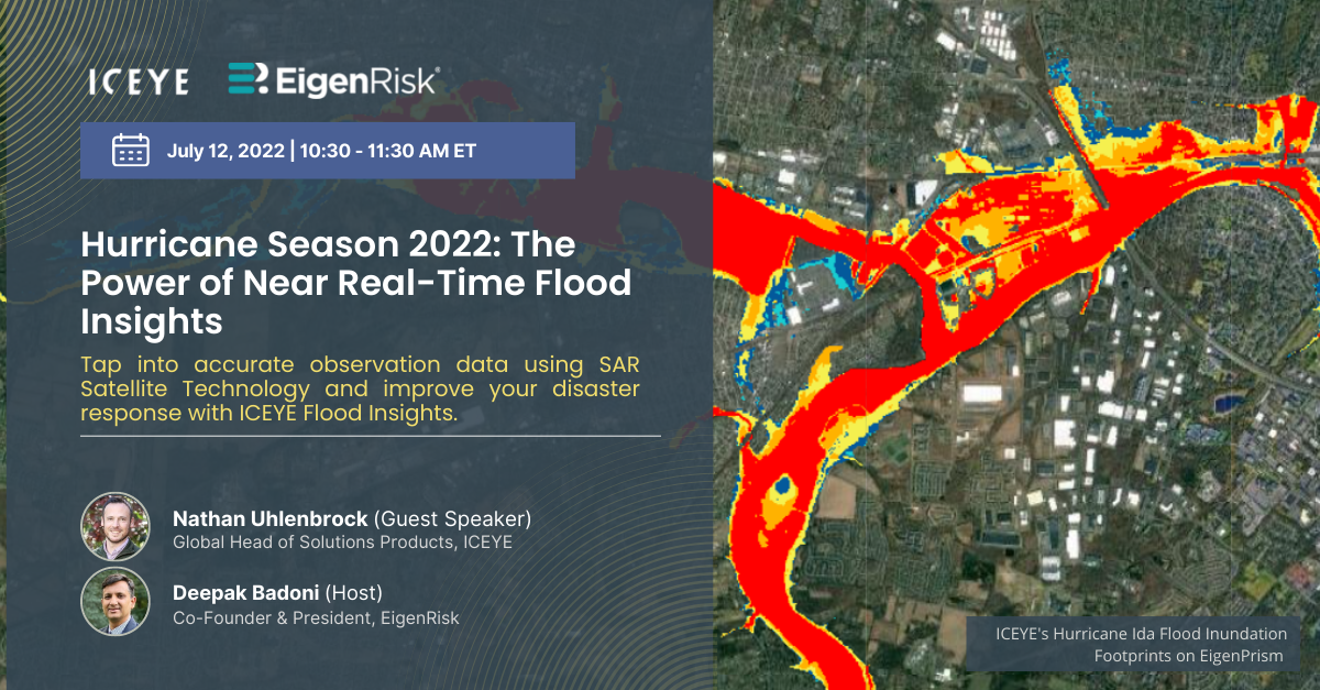
In a webinar hosted by Deepak Badoni, president, EigenRisk, Nathan Uhlenbrock, Global Head of Solutions Products, ICEYE discussed how his firm is using Synthetic Aperture Radar (SAR) technology in combination with other resources to generate accurate flood data within 24 hours of an event, including frequently updated flood footprints.
Headquartered in Helsinki, Finland, ICEYE has more than 400 employees and operates globally.
Using SAR technology, ICEYE’s fleet of satellites can provide near real-time imagery of flooding on a global basis through clouds, darkness, smoke and volcanic ash.
Badoni and Uhlenbrock highlighted three ways flood footprints help facilitate more effective disaster response and claims management:
- Situational awareness, including event monitoring (and near misses), filtering out noise from the news cycle.
- More accurate loss sizing, resulting in tighter reserving and cash calls, and reduced loss creep (such as flooding affecting second homes where homeowners aren’t aware of a potential loss).
- Smarter claims response, which supports proactive customer engagement, smarter resource allocation in deploying adjusters, and fraud detection by overlaying flood footprints with portfolios.
Uhlenbrock contrasted ICEYE’s flood imaging solution set with resources currently available from popular flood modeling providers.
Actionable insights. Uhlenbrock explained that although ICEYE doesn’t generate pre-flood models, it leverages data from multiple sources to identify areas that might be subject to flooding. That information, in turn, helps drive the deployment of its vast SAR-equipped satellite constellation. ICEYE then integrates its satellite imagery with hydrological and digital terrain data and building footprints to create actionable flood insights, including depth impacting individual properties.
By deploying its satellites equipped with SAR technology, ICEYE can provide updated images of specific flood areas anywhere in the world every three hours. In addition, using analytics powered by AI, the company can convert raw data into flood depth within 24 hours.
Badoni showed how ICEYE’s fully integrated flood imprints can be displayed on the EigenRisk platform, including automated updates every 24 hours. Next, Uhlenbrook explained how ICEYE provides transparency with respect to the confidence level of flood depth estimates.
Accurate exposure data is key. Badoni emphasized the need to have accurately coded exposure data prior to any loss event and mentioned many EigenRisk users now take advantage of an API to automatically update their data.
The good news is that EigenRisk users only need to update their exposure data once to have accurate information available for a wide range of loss events, including hurricane, flood, storm surge, wildfire and other natural catastrophes.
Uhlenbrock concluded with a brief discussion of other applications for ICEYE’s SAR technology, including infrastructure, such as pre-loss assessments of bridges and mining locations, as well as its use for other perils beyond flooding, including fire and, in the future, wind.
Want to learn more?
To access the entire webinar, click here. To arrange a discussion and a demonstration of ICEYE’s flood assessment capabilities readily accessible on the EigenRisk platform, please contact us:


