

US Wildfires – Western States Impact Summary
As the heat wave continues across the western US, major wildfires are burning across much of the region.
Currently, 92 large fires have burned nearly 1.2 million acres in 14 states. About 25,000 wildland firefighters and support personnel are assigned to incidents across the country. Critical weather conditions caused several fires in California to gain tens of thousands of acres. Evacuation orders are in place for residents near wildfires in Arizona, California, Colorado and Oregon.
National InterAgency Fire Center
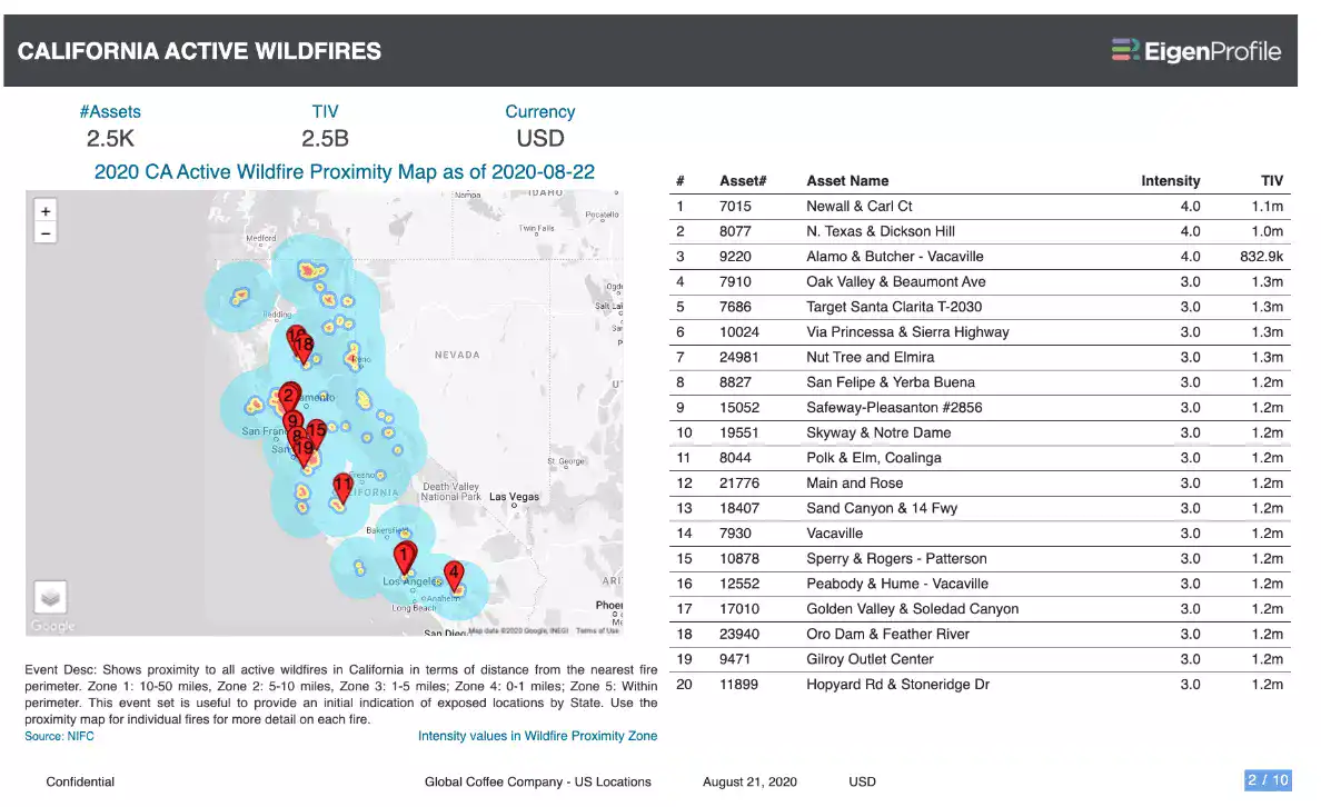
Wildfire proximity maps provide the proximity of any location to the current perimeter of an active wildfire, and are useful as an early warning to surface exposure in the vicinity of wildfires. Proximity maps are available in EigenPrism for both the state and for individual wildfires.
Assessing the impact
An impact summary template report is now available in EigenPrism containing the state proximity maps for California, Nevada, Oregon, Washington, Arizona, Utah, Idaho, Wyoming and Montana. EigenPrism users can copy the template report and apply it to their own exposure:
- Open the impact summary report – SAMPLE Western States Wildfire Impact Summary
- or, search for the “SAMPLE Western States Wildfire Impact Summary” on the EigenPrism home page
- then click Manage > Copy to select your workspace and save with your own exposure
Please note, as report templates are frequently updated, you can refresh the report by changing the Analysis Date. See instructions here.
EigenAlerts provide automated notifications via email and text message with key metrics to estimate impact:
Don’t have access to EigenPrism?
Sign up for a trial account and access full impact reports of all events. Contact us and we’ll set up a trial account for you.
More on event news:
- CALIFORNIA WILDFIRES
- EARTHQUAKES IN PHILIPPINES, INDONESIA
- HURRICANE GENEVIEVE
- MIDWEST DERECHO FOOTPRINT
- MIDWEST DERECHO


