

Real-Time Data Assessing Irma’s Impact
Given the size and severity of Hurricane Irma – currently one of three active tropical weather systems in the Atlantic region – it’s critically important to have the best available real-time data when assessing the potential impact on your program or portfolio.
The examples below show how different real-time data sets can be used for different types of pre-event analyses, while this case study from Guru Rao, FB Alliance’s Chief Data and Analytics Officer, describes how an insurance company is using technology and automation to implement real-time catastrophe response.
Estimating Location Loss – with Wind Probabilities
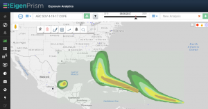 This event set depicts the probability of winds exceeding hurricane strength (64 knots) at any given location over the next 120-hr period. It is useful when assessing the relative risk of hurricane force wind at any single location. It is not intended be used to estimate aggregate risk.
Estimating Aggregate Impact – with Maximum Wind Forecasts
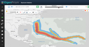 This event set provides a complete wind-speed footprint. The 5-day forecasts of maximum wind-speeds (peak gusts) are merged with past winds. It contains an approximation of peak gusts that can be used for pre-event damage estimation.
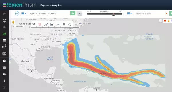
In a rapidly changing environment, stay current with real-time data
The combination of wind, flood and storm surge data available in the EigenPrism real-time event catalog will help you obtain the most complete assessment of how your program or portfolio may be impacted – and because the data is available in real-time, you will stay current as the forecasts are updated.
EigenAlert subscribers will continue to receive automated notifications with key metrics as these events progress.
If you are not a subscriber, and would like to learn more:
![]()
Uncertainty in Hurricane Irma forecast track
Hurricane forecasts naturally include uncertainty. The farther out the forecast, the greater the uncertainty. The NHC estimates average errors in the track 4 to 5 days out are between 175 and 225 miles, which can make a large difference in the impact of the storm at landfall.
This article explains the differences between the NHC forecasts and the the European Center for Medium-Range Weather Forecasts.
Irma is currently expected to turn north by this weekend, but where that northward turn will occur is critical for determining the impact Irma may bring to parts of the southeastern United States.
The conditions needed to support intense hurricanes – wow wind shear, increased mid-level moisture and warm sea surface temperatures – remain in place, making it very likely that Irma will remain a powerful hurricane (Category 4 or stronger) for the next several days, though some intensity fluctuations are likely at times.
For the next five days, Irma will move west-northwest on the south side of a ridge of high pressure called the Bermuda high, centered in the central Atlantic.
While it is still too soon to narrow down specifics on the exact path of Irma’s center and eyewall, there is an increasing chance of a major hurricane strike on at least part of South Florida, including the Florida Keys, this weekend.
As a Category 5 hurricane  with sustained winds of 185 miles per hour, Irma now ranks among the most powerful hurricanes (as measured by wind speed) ever recorded. Irma has sustained these 185 mph winds for more than 24 hours, a record length of time. And it’s one of the most powerful cyclones to ever make landfall.


