

Nicholas Continues to Threaten Louisiana and Gulf Coast States with Flooding Rainfall
Sep 15
Category 1 Hurricane Nicholas’ landfall in Texas brought heavy wind, rain and dangerous storm surge threats. According to National Hurricane Center, a storm surge of 3 to 6 feet was observed on the upper Texas coast on Tuesday with highest surge around Galveston Bay. The maximum sustained winds were around 75 mph. At its peak, more than 500,000 businesses and homes faced power outages in southeast Texas, including the Houston area.
Despite weakening after landfall, Nicholas continues to spread its threat of flooding rain from Southeast Texas into Louisiana, Mississippi, Alabama, and Florida Panhandle into the next few days.
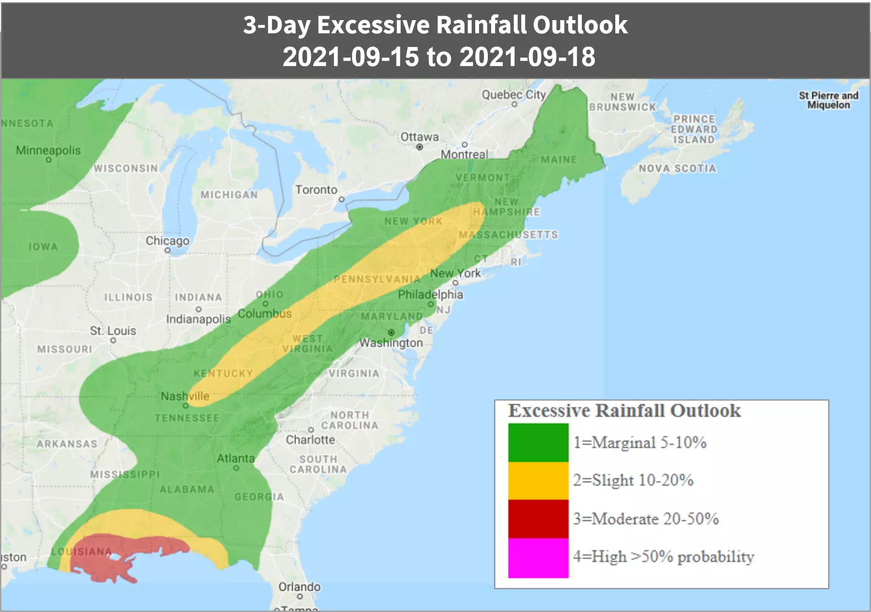
As per the NHC, Nicholas is currently located about 55 miles of Lake Charles Louisiana with maximum sustained winds of around 35 mph. The center of Nicholas is tracking inland east-northeastward from the Gulf Coast. Locally heavy rainfall of 5 to 10 inches extends to the east of that center into Louisiana, southern Mississippi and southern Alabama and the Florida Panhandle.
Nicholas will further weaken as it glides into Louisiana through Thursday.
Follow the quick links to assess the impact in EigenPrism:
- Depression Nicholas Past Wind Swath (Advisory 12) – as of 2021-09-15
- WPC 3-Day Excessive Rainfall Outlook – from 2021-09-15 to 2021-09-18
Sep 14 | Hurricane Nicholas Makes Landfall on Texas Coast, Bringing Heavy Rain and Storm Surge
Nicholas made landfall at 1 am (local time) on Tuesday as a Category 1 hurricane with maximum sustained winds of 75 mph about 20 miles northeast of Matagorda, Texas. The NHC also reported a storm surge of 3 to 4 feet above normal tide levels observed this morning on the upper Texas coast, including around the Galveston Bay area. More than 300,000 homes and businesses faced power outages in southeast Texas, including the Houston area.
The storm is moving over southeastern Texas, making its way to southwestern Louisiana later Wednesday, where it is expected to weaken, as per the NHC.
As per the NHC, the current location of Nicholas is about 30 miles SSW of Houston Texas with maximum sustained winds of 70 mph. Meanwhile, bands of heavy rain and gusty winds continue to pound the upper Texas coast and parts of Louisiana. Nicholas will spread its threat of flooding rain from southeast Texas into Louisiana and Mississippi into this week.
Follow the quick links to assess the impact in EigenPrism:
- Hurricane Nicholas Past Wind Swath (Advisory 09) – as of 2021-09-14
- WPC 3-Day Excessive Rainfall Outlook – from 2021-09-14 to 2021-09-17
- Tropical Storm Nicholas 2021 Storm Surge Potential excl. Levees (Advisory #009) – as of 2021-09-14
Sept 13 | Tropical Storm Nicholas Strengthens, Threatening Texas and Louisiana with Flooding Rainfall
Tropical Storm Nicholas is predicted to be a major rainfall flood threat to parts of the Texas and Louisiana coasts and will bring strong wind gusts and storm surge. The storm is already producing widespread showers and thunderstorms throughout a broad area of the western Gulf of Mexico right now. Some bands of rain from Nicholas have spread into the Texas and Louisiana coasts.
According to the National Hurricane Center, the current location of Nicholas is about 210 miles south of Port O’Connor, Texas. It will make landfall along the middle Texas coast tonight.
A hurricane watch is also now in effect for a part of the middle Texas coast, from Port Aransas to Freeport. Hurricane conditions could occur in this area as early as this afternoon.
After landfall, Nicholas should make its way to the northeast and then east over eastern Texas into Louisiana. As per the NHC, it will then weaken to a tropical depression.
Follow the quick links to assess the impact in EigenPrism:
- Tropical-Storm-Force (>34 kt) Wind Probabilities – from 2021-09-13 to 2021-09-18
- Tropical Storm Nicholas Storm Surge Potential(Advisory #005) – as of 2021-09-13
- Tropical Storm Nicholas Storm Surge Potential excl. Levees(Advisory #005) – as of 2021-09-13
- 3-Day Excessive Rainfall Outlook valid from 2021-09-13 to 2021-09-16
Sept 12 | Nicholas to Bring Rainfall and Strong Winds to Texas and Louisiana
Tropical Storm Nicholas formed in the western Gulf of Mexico today. According to the National Hurricane Center, it will track toward the Texas and Louisiana coasts, triggering threats of flooding rainfall, strong wind gusts and storm surge through midweek.
In addition to that, a tropical storm warnings are issued along the coast of Texas from Port Aransas to the Mouth of the Rio Grande. A tropical storm watch is also in effect in the Texas coast from north of Port Aransas to High Island. These areas could see tropical-storm-force winds by late Monday night or early Tuesday.
The current location of Nicholas is about 405 miles south-southeast of the border between Texas and Mexico. It is producing widespread showers and thunderstorms throughout the western Gulf of Mexico. After that, it will track north and then northeast near or just off the coasts of northeast Mexico and Texas through early this week
Follow the quick links to assess the impact in EigenPrism:
- Tropical-Storm-Force (>34 kt) Wind Probabilities – from 2021-09-12 to 2021-09-17
- Tropical Storm Nicholas Storm Surge Potential(Advisory #001) – as of 2021-09-12
- Tropical Storm Nicholas Storm Surge Potential excl. Levees(Advisory #001) – as of 2021-09-12
- 3-Day Excessive Rainfall Outlook valid from 2021-09-12 to 2021-09-15
Don’t have access to EigenPrism?
Sign up for a trial account and access full impact reports of all events. Contact us and we’ll set up a trial account for you.


