

Tropical Depression Fred Poses Threat of Flooding and Rain Into the Southeast
August 17
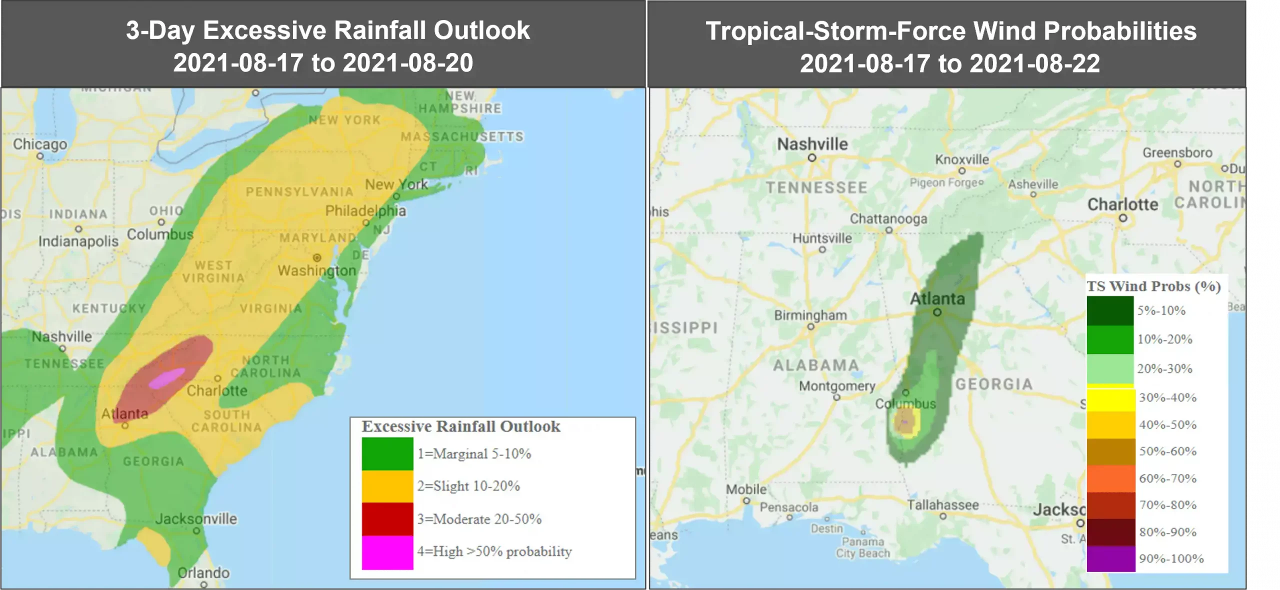
Tropical Storm Fred downgraded to a depression today over extreme Southeastern Alabama. According to the National Hurricane Center (NHC), it is tracking inland across portions of Alabama and Western Georgia across the Southern Appalachian mountains. Fred it is currently located 15 miles SSW of Columbus Georgia with maximum sustained winds of 35mph.
Bands of heavy rain packing gusty winds are spreading from Georgia into Southern Appalachians as Fred tracks further inland.
By the middle of the week, Fred or its remnants will lift Northward and impact the Central Appalachians and mid-Atlantic. Landslides are also possible across the mountains of North Carolina and Blue Ridge Escarpment today.
According to the National Weather Service, a tornado watch has been issued for North and Central Georgia including much of metro Atlanta, Macon and Athens.
On Monday, Fred made a landfall near Cape San Blas, Florida, at 2:15 p.m. (local time) with maximum sustained winds of 65mph. More than 7 inches of rain was measured in Panama City and Recota Beach while widespread flooding was observed in Southport through Monday evening.
Follow the quick links to assess the impact in EigenPrism:
- Tropical-Storm-Force (>34 kt) Wind Probabilities – from 2021-08-17 to 2021-08-22
- TropStorm Fred Forecast Wind Swath Advisory 30A – as of 2021-08-17
- Tropical Storm Fred 2021 5-day Forecast Max Winds – as of 2021-08-17
- WPC 3-Day Excessive Rainfall Outlook – from 2021-08-17 to 2021-08-20
August 16
According to the National Hurricane Center (NHC), Tropical Storm Fred has strengthened and is moving through the eastern Gulf of Mexico, heading for a landfall in the Florida Panhandle later today, where it is expected to bring flooding rain and gusty winds. Potential rainfall and flooding from Fred will also spread inland across parts of Georgia, Alabama and western Carolinas.
Fred had downgraded to a depression but regained its tropical storm status Sunday morning over the Gulf of Mexico, and is predicted to gradually increase its strength as it tracks through the Gulf of Mexico today.
Currently, Fred is centered about 90 miles SSW of Apalachicola, Florida and is tracking north-northwards with maximum sustained winds of 50mph.
A tropical storm warning has been issued for parts of the Florida Panhandle, including Panama City. The storm is expected to bring dangerous storm surge, river flooding and potential tornadoes when it reaches the US coast, where it is forecasted to weaken after landfall, according to the NHC.
According to US Federal Emergency Management Agency (FEMA), a state of emergency has been declared for 23 counties across Florida.
Follow the quick links to assess the impact in EigenPrism:
- Tropical-Storm-Force (>34 kt) Wind Probabilities – from 2021-08-16 to 2021-08-21
- TropStorm Fred Forecast Wind Swath Advisory 27 – as of 2021-08-16
- Tropical Storm Fred 2021 5-day Forecast Max Winds – as of 2021-08-15
August 12
Tropical Storm Fred weakened to a tropical depression late Wednesday. According to the National Hurricane Center (NHC), Tropical Depression Fred moved back over water between eastern Cuba and the southeastern Bahamas, where it is expected to remain disorganized for the next few days. It is forecasted to strengthen again before reaching the US coastline.
It is currently located 80 miles east of Guantanamo Cuba with maximum sustained winds of 35mph.
Heavy rain continues to pour over Haiti and the Dominican Republic which could lead to flash, urban and small stream flooding, along with possible rapid river rises and potential mudslides. Tropical storm conditions are possible in northern Haiti and the southeastern Bahamas this morning and in portions of Cuba later today.
Beginning early Saturday, there is a risk of tropical storm conditions in the Florida Keys and South Florida. Heavy rainfall associated with Fred will impact the remainder of Florida and parts of Southeast this weekend and into the next week.
Follow the quick links to assess the impact in EigenPrism:
- Tropical-Storm-Force (>34 kt) Wind Probabilities – from 2021-08-12 to 2021-08-17
- Depression Fred Forecast Wind Swath Advisory 11A – as of 2021-08-12
- Tropical Storm Fred 2021 5-day Forecast Max Winds – as of 2021-08-11
August 11
Tropical Storm Fred developed off the coast of Puerto Rico on Tuesday night, becoming the sixth named storm of the 2021 Atlantic season. According to the National Hurricane Center (NHC), the storm is located about 50 miles SE of Santo Domingo, Dominican Republic, with maximum sustained winds of 40mph with higher gusts.
It is currently tracking towards the west near Puerto Rico and is expected to interact with Hispanola today, where it will likely weaken before reaching the Turks, Caicos Islands and southeastern Bahamans on Thursday. By Friday, Tropical Storm Fred will impact the US starting with South Florida, potentially making landfall over the Florida Keys. It is not predicted to strengthen into a hurricane, however, that can change as the storm progresses.
Heavy rainfall of 2 to 4 inches is expected over Puerto Rico and the Dominican Republic, which could lead to flash, urban and small stream flooding, along with possible rapid river rises and potential for mudslides over the next few days.
Follow the quick links to assess the impact in EigenPrism:
- Tropical-Storm-Force (>34 kt) Wind Probabilities – from 2021-08-11 to 2021-08-16
- TropStorm Fred Forecast Wind Swath Advisory 07A – as of 2021-08-11
- Tropical Storm Fred 2021 5-day Forecast Max Winds – as of 2021-08-11
August 10
Follow the quick links to assess the impact in EigenPrism:
- Tropical-Storm-Force (>34 kt) Wind Probabilities – from 2021-08-10 to 2021-08-15
- Depression Six Forecast Wind Swath Advisory 04 – as of 2021-08-10
Don’t have access to EigenPrism?
Sign up for a trial account and access full impact reports of all events. Contact us and we’ll set up a trial account for you.


