

Extreme flood risk as Hurricane Florence makes landfall in North Carolina
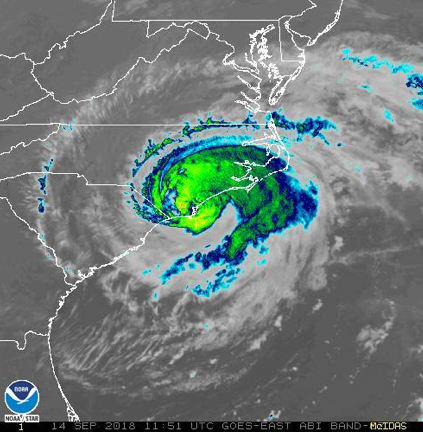
Hurricane Florence made landfall in North Carolina this morning as a Cat 1 storm, and as predicted, the slow moving storm is exposing the coast to high storm surge and heavy rainfall as well as 90-mph winds.
The WPC excessive rainfall outlook for today shows the extent of the area at risk of flash flooding; the pink area on the map is the high risk zone, with probability greater than 50%. The coastal area, especially around New Bern, is also receiving storm surge that in some areas has been recorded at 9 feet.
Major impact: flood risk
Our data partner Meteorological Connections has provided the following discussion:
According to the National Hurricane Center, Hurricane Florence is a CAT 1 storm that is moving to the west at 5 Kts (6 mph)…some slowing has occurred in the past six hours.
Hurricane Florence made landfall with 90 mph winds about 7:30a near Wrightsville Beach to the south of Wilmington. Models have been quite good at predicting landfall near Wilmington the past several days. Official peak surface wind report of 105 mph gust at Wilmington.
The major impact has been flood inundation from sea level rise and onshore winds from the center of the storm well to the north. The NHC forecasts a very slow westward motion and slow weakening the next 24 hours as Hurricane Florence remains near shore or just offshore along the NC coast. In 24 hours, the system is expected to be just north of Myrtle Beach as a TS or a Cat 1 system. The large and persistent circulation will continue heavy to extreme rainfall across much of eastern North Carolina that moves west and north through the day. In some locations, well over ten inches of rain has fallen and 10 to 15 inches are expected in much of central and eastern NC today and the rains will continue into Saturday / Sunday. Some locations will approach 40 inches depending on how the bandings sets up.
Persistent and long duration onshore winds will continue through the day in most of the same areas that have already received many hours of rain. The heavy rain and winds will move into Myrtle Beach around mid day.
Assessing the impact
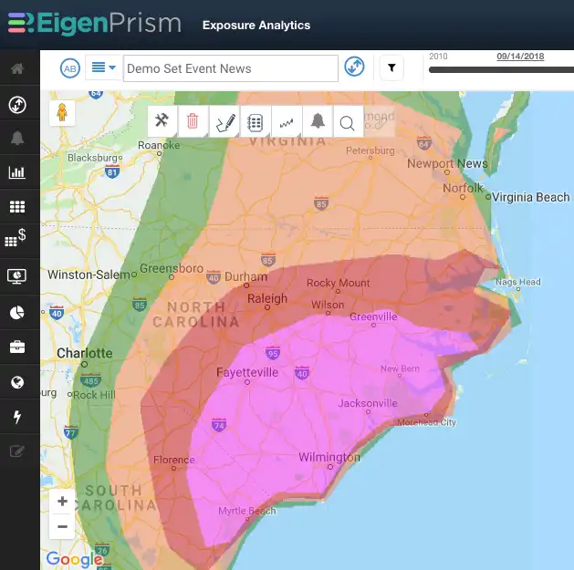
For Hurricane Florence, EigenPrism users have a comprehensive set of event data covering wind, storm surge and rainfall. They can select the perils most applicable to their exposure sets, and then set customized thresholds for each peril and exposure set Alert. Thresholds can be set using a variety of metrics, including number of assets, impacted values, ground up loss, and damage factors. The result is smart Alerts that assess the impact for you,
- EigenAlerts provide automated notifications with key metrics to estimate impact
- Customized and mobile enabled
- Updated as forecasts and advisories change
And automated forecast Impact Report templates make pre-event analysis available in minutes.
Contact us if you want to use EigenAlerts immediately; you can be up and running in a day if you have data in standard cat model or spreadsheet format.
Arrange a live demo
Not a subscriber, but want to see how this works? Contact us and we’ll set up a live demo to show you how EigenPrism helps you plan, monitor and respond to nat cat events.
[wpforms id=”2114″]


